The Boulder Bank
|
Description
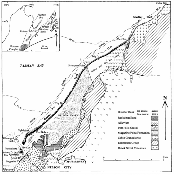
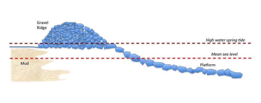
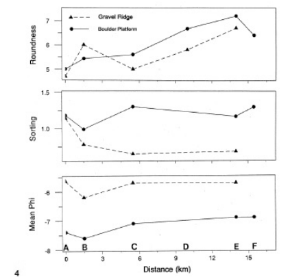
The Boulder Bank is a 13 km barrier that runs from MacKay Bluff in the east to The Cut, opposite Magazine Point in west Nelson (Figure 1), Away from MacKay Bluff, it lies 1-2 km offshore, and contains a tidal water area known as Nelson Haven. In plan, the bank is curvilinear, and runs more-or-less parallel to the foot of the Richmond Hills. In cross-section, it is seen to consist of two units: a lower platform that rises out of the mud ca. 300-600 m offshore, and rises to just below mean tide level, and an upper ridge that rises to about 5 metres above high tide (Figure 2). Both units are composed predominantly of granodiorite coasts, similar in lithology to the rocks of MacKay Bluff - the Cable Granodiorite. In the ridge, the material is well-sorted, and tends to become finer and more rounded with distance, westwards from MacKay Bluff (Figure 3). Clasts in the platform deposits are less well-sorted and sub-rounded to sub-angular, and size reduction to the south-west is less distinct. |
The age of the deposits has been estimated using radio-carbon dating of shells obtained from the platform sediments. These give dates of 7165-7461 years BP, but the shells are mixed and somewhat worn and appear to have been reworked from older deposits. Similar dates have also been obtained from an estuarine fauna in Nelson Cut (7796 years BP). Together, therefore, the dates suggest that the Bank began to develop ca. 7000 years ago, as the the sea level rouse following the Last Glaciation, to its present height.
|
Origin
Initial interpretations of the Boulder Bank suggested that it had been formed by longshore drift of material from MacKay Bluff. This is constant both with the lithology of the deposits and the size and shape sorting from north-east to south-west. If this interpretation is true, the Bank is a notable example of a spit, though not particularly remarkable. For various reasons, however, doubts about this explanation have arisen, mainly due to the large size of the clasts. Whilst the finer sediments are well within the range of material that can be moved as bedload by present-day tides, the coarsest boulders (up to 2 meters in diameter) seem to be too large to be transported any distance. In this case, it has to be assumed that the Boulder Bank is, at least in part, a fossil feature, and that the coarser material was laid down in a more energetic sedimentary environment. Considerable debate has therefore flourished about the origins of the Boulder Bank (and likewise of the similar feature in Cable Bay). This debate continues .Two main theories have been proposed: |
1) That the Boulder Bank has been formed primarily by longshore drift. In this theory the assumption is that the larger cobbles and boulders have been transported south-westwards mainly during storms. Evidence to support this includes:
2) That the Boulder Bank is - in part at least - a fossil feature. This theory assumes that, while the ridge on the top of there bank is the result of longshore drift during the Recent period, the underlying platform deposits are derived from an older boulder bank a little further out to sea. Evidence to support this includes:
- only available source for granodiorite class is the Cable Granodiorite, to the north-east;
- observation by local residents suggests that individual boulders come and go between storms; one boulder (1 metre in length) moved 25 metres in three years. (Note: movement of these boulders is not necessarily a direct result of the force of the water, but indirect: waves and tides transport the smaller fragments on which the boulders rest, causing them to slip into the depression;
- boulders that might have moved in this way have built up a lag deposit which caps the platform deposits in places;
- distinct size and shape sorting of ridge in south-westerward direction..
2) That the Boulder Bank is - in part at least - a fossil feature. This theory assumes that, while the ridge on the top of there bank is the result of longshore drift during the Recent period, the underlying platform deposits are derived from an older boulder bank a little further out to sea. Evidence to support this includes:
- the lack of any great change in the geometry of the gravel platform since the first detailed survey in 1850;
- the presence of encrusting organisms and weathering rinds on the boulders which shows that they are currently immobile
- the platform gravels at the southwestern end of the bank are significantly more weathered than those at the Mackay Bluff end, suggesting that they have weathered in situ, over a long period of time;
- the lag deposits are the result of erosion of the finer material from the platform - indicating that the coarser coasts have not been moved;
- insufficient wave energy to move the largest clasts.
Interpretation
Which of these two theories you believe is a matter of choice. The longshore drift theory requires evidence to show that the coarser materials that make up the platform deposits could have moved in this way at some time over the last 7000 years or so. The dual theory - which sees the platform deposits as a result of erosion of an older gravel bank - requires evidence for the existence of these deposits, and an explanation of how it formed. It is, though, interesting to debate the conflicting theories as you explore the Boulder Bank.
Which of these two theories you believe is a matter of choice. The longshore drift theory requires evidence to show that the coarser materials that make up the platform deposits could have moved in this way at some time over the last 7000 years or so. The dual theory - which sees the platform deposits as a result of erosion of an older gravel bank - requires evidence for the existence of these deposits, and an explanation of how it formed. It is, though, interesting to debate the conflicting theories as you explore the Boulder Bank.
What to see on the Boulder Bank |
More information |
|
The Boulder Bank shows a range of interesting features characteristic of marine beaches of this sort. These include:
Other places to see boulder banksCable Bay: a similar feature, forming a barrier across a bay, that is subject to the same processes.
|
Dickinson, W., Hartstein, N., Warren, K. 2011. Geology and History of the Nelson Boulder Bank. In: Lee, J.M. (ed). Field Trip Guides, Geosciences 2011 Conference, Nelson, New Zealand. Geoscience Society of New Zealand Miscellaneous Publication 130B. 18 pp
Hartstein, N.D. and Dickinson, W.W. 2006 Wave energy and coast transport in eastern Tasmania Bay, New Zealand. Earth Surface Processes and Landforms 31, 703-714. Johnston, M.R. 2001 Nelson boulder bank, New Zealand. New Zealand Journal of Geology and Geophysics 44, 79-88. |


